By Viktor Filas | Khortytia National Academy, Zaporizhzhia, Ukraine
Description
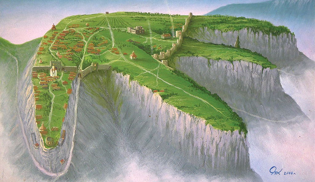
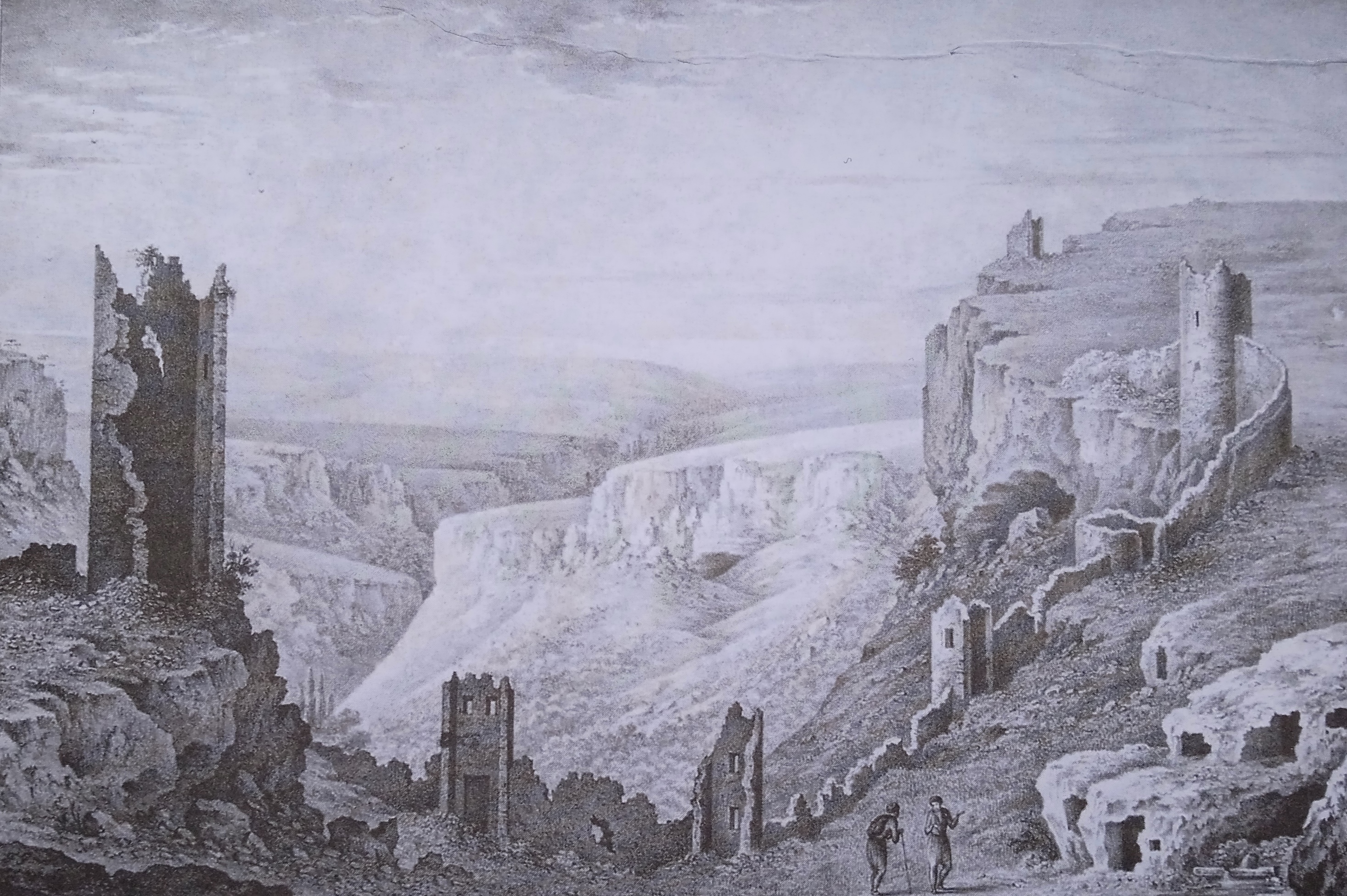
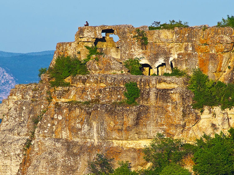
Mangup-Kale is the largest medieval fortress within the group of so-called “cave towns” of the South-Western Crimea. The first settlements on Mangup-Kale appeared at the end of the 3rd century. This territory continued to be inhabited until the end of the16th century. The fortress is located on the top of an isolated plateau about 600 m above sea level. The total area of Mangup is about 90 hectares, which is limited on all sides by vertical rocky cliffs with a depth of 30 to 70 m. From the north, the Mangup plateau is cut by three deep gorges with four protruding rocks. There is only one connecting road and several paths laid along the bottom of the gorges from the Karalezka valley that can be used to climb to the settlement. Abundant streams originate in the upper reaches of the beams. The high degree of natural protection, the vast size, and the presence of water sources were the main reasons for the adaptation of this rocky plateau of the Crimean foothills as a fortification and settlement.
The most common version of the origin of the name “Mangup” has come down to us in the Ottoman legend, retold by the traveler Evliya Çelebi in 1665. He wrote: “Even after the Crimean country was conquered, this fortress was in the hands of the infidels for seven years. Gedik Ahmed Pasha put so many soldiers here that because of this he himself died from the wrath of the Sultan. Therefore, this fortress was called in Turkish menkûp – that is, “ill-fated”.
In the history of the Christianization of the outskirts of the Byzantine Empire, the Mangup settlement played a paramount role. Already from the moment the region was included in the zone of political influence of the Byzantine Empire in the 7th century, the settlement quickly turned into one of the most important centers for the spread of Christianity. After the emergence of an independent Gothic bishopric on Mangup in the 8th century, which was the territorial unit of the Orthodox Church headed by a bishop, and until the Ottoman conquest of the Crimean peninsula in 1475, there was a cathedral church and the residence of the hierarch of Crimean Gothia. Such a church-administrative status became one of the main reasons for the appearance of many Christian places of worship on the territory of the settlement. Today, within the Mangup plateau, on its slopes and in the nearby mountain valleys, 27 Christian rock and ground temple-burial and monastic complexes have been identified. Among the most significant Christian architectural objects are: Great Basilica, “Cruciform Temple”, “Markevich’s Basilica”, “Church 2015”, “Church 1967”, “Church 2005”, “Southern minor basilica”, Northern Cave Monastery, the temple inside the Mangup Citadel, Southern Cave Monastery, churches St. Constantine and St. George. There are also archaeological complexes Almalyk burial ground and the Teshkli-Burun treasure.
Significance
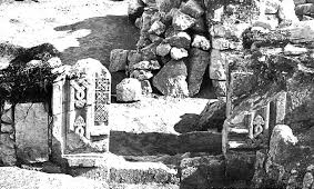
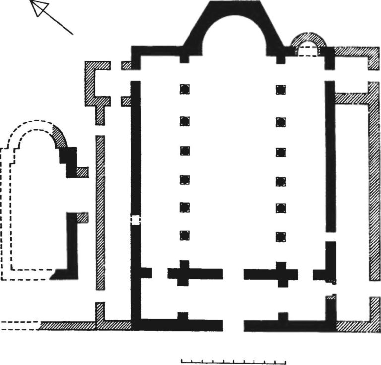
The beginning of the Christianization of Mangup is connected with the beginning of the construction of a Byzantine fortress on the Mangup plateau at the end of the reign of Emperor Justinian I (527–65). At the same time, the Great Basilica with three naves was built, which served as the administrative and religious center of the settlement. The layout, size, decor, and the separate baptistery, discovered during archaeological research, which began in 1850 and is still being conducted from time to time, indicate that this basilica was likely the center of the episcopal architectural complex.
Despite the support of the Byzantine administration, details about the rapid spread of the new religion in the second half of the 6th – early 7th centuries remain elusive. There are only two archaeological Christian complexes on the site of this period. In one of the family crypts of the Almalyk burial ground, a carved Christian cross with expanding ends was found. No less interesting is the “Teshkli-Burun treasure”, which included, in addition to various gold ornaments (jewelry?), a gold cross with a garnet insert.
Starting from the second half of the 7th century, there had been a sharp increase in the size of the Christian community of Mangup. The creation of the Gothic bishopric at the end of the 7th century and the inclusion of Mangup in the Byzantine theme in 841 formed new conditions for the transformation of the sacred space of the city.
In the southern part of Mangup, early medieval burial grounds ceased to function and two new large religious complexes appeared. These sites had compositional and planning features typical of Byzantine architecture. Since the names of these structures have not been preserved, they are usually called the “Cruciform Temple” and “Markevich’s Basilica”. These churches, together with the burial complexes of the Great Basilica of Mangup, testify to the “Byzantization” and the Christianization of the local population. At the turn of the 12th–13th centuries, new monasteries such as Northern Cave Monastery were built, or the already existing old temple complexes were rebuilt.
At the end of the 13th century, the Gothic bishopric received the rank of metropolis and a new stage began in the history of the formation of the sacred space of Mangup and its Christian history. This stage was accompanied by the construction of many religious sites and monastery complexes. It is important to note that during this period, Mangup had already left the subordination of Byzantium and was ruled by the ulus administration of the Crimean Yurt of the Golden Horde. In 1395, detailed topographic descriptions of Mangup were made by Hieromonk Matthew, who noted the urban character of the settlement on the Mangup plateau. He mentioned the outer church of the main fortress gate, basilicas, round and domed churches in the central part of the fortress. “... I saw outstanding temples, paved with mosaics. And domed, basilic-like and round according to the position (building) of the local metropolis ... as soon as I entered the tower and saw the buildings position, the most beautiful temples and the beauty of palaces, rock-cut tombs, porticos and columns ...” To study Mangup, in addition to the archaeological research, written sources are no less important, giving an idea of the variety of monuments of the fortress and containing value judgments of contemporaries about the urbonymic space of Mangup.
Modern archaeological research confirms the abundance and diversity of Christian religious complexes that appeared in the Golden Horde period. In addition to the Great Basilica, there were also several above-ground churches in the 13th–14th centuries. These unnamed places of worship, named after the year they were researched, include “church 2015”, “church 1967”, and “church 2005” with a “southern minor basilica”. During this period, a significant part of the rock temples and monasteries was also cut down. Among them stand out the North-Eastern Monastery, the garrison church on Cape Teshkli-Burun and the South-Eastern Monastery on the esplanade of the Mangup Citadel.
As a result of the Crimean campaign of the founder of the Timurid Empire Timur (1336-1406) (or his protege Edigey) in 1395 during the war against the Khan of the Golden Horde Tokhtamysh (1342–1406), a significant part of Crimea was devastated, including the most important urban centers of the peninsula – Chersonese, Solkhat, Kaffa, and Mangup. The Mangup churches were completely dismantled, and the burial grounds were abandoned. At the beginning of the 15th century, Mangup became the capital of the Principality of Theodoro (ruling dynasty of the Principality of Theodoro that existed in the Crimea from 1223 to 1475), and its sacred space was significantly altered. The Great Basilica retained its status as the cathedral church of the Gothic metropolis. The temple inside the Mangup Citadel and the Southern Cave Monastery, which were directly related to the ruling dynasty of princes of Theodoro, receive great importance in the life of the city. In the upper reaches of the Kapu-dere and Gamam-dere beams, the churches of St. George and St. Constantine were built, and possibly the “church of 1969” with necropolises.
After the inclusion of the Mangup fortress into the Ottoman Empire in 1475, the ethnic and confessional composition of the population was changed, as well as the sacred topography of the city. According to the defter (registry of population, land and income) of 1520, by the beginning of the 16th century Muslim, Armenian, Jewish, and Greek Orthodox communities lived side-by-side. The Christian community was half of the city’s population and consisted of six quarters. Each quarter had its own church and necropolis. The results of archaeological research so far speak of only two churches, which had been already mentioned – St. Constantine and St. George.
By the end of the 16th century, the Christian community began to decline. The traveler Martin Bronevskij, describing Mangup in 1578, wrote about one active church – St. Constantine. “Now only the Greek church of St. Constantine and another St. George, completely worthless, remain there.” By the middle of the 17th century, the defters no longer recorded the Christian population on Mangup. The last-standing churches were dismantled, and the cave churches and monasteries of the city fell into disrepair.
Throughout the entire period of the Middle Ages, Mangup-Kale was one of the most important centers for the spread of Christianity in the Crimean outskirts of the Byzantine Empire. There were the residence and the cathedral church of the hierarchs of the Gothic bishopric of the Constantinople Patriarchate. This fortress played a role in the preservation of Christian traditions in the “post-Byzantine” time in Crimea, as evidenced by the numerous Christian churches and monasteries discovered over the years during archaeological excavations.
Further Reading
Barmina, Nadezhda. “Arheologicheskoe izuchenie Mangupskoj baziliki v 1850–1930-e gg. (istochnikovedcheskij aspekt)” [Archaeological study of the Mangup Basilica in the 1850–1930s (source aspect)]. Antichnaya drevnost’ i srednie veka (2009): 409-422.
The article contains an analysis of the results of archaeological research of the Mangup Basilica, carried out by F. A. Brown (1890), R. Ch. Leper (1912-1914) and M. A. Tichanova (1938).
Gercen, Aleksandr i Valerij Naumenko. “Sakral’naya topografiya Mangupa: istoriya izucheniya, katalog i periodizaciya kul’tovyh pamyatnikov gorodishcha” [The sacral topography of Mangup: research history, catalogue, and periodization of religious monuments discovered in the ancient city]. ΧΕΡΣΩΝΟΣ ΘΕΜΑΤΑ. Miry Vizantii 2 (2019): 115-176.
This paper presents a comprehensive study of the sacral topography of ancient Mangup as the largest mediaeval fortress in the South-Western Crimea. It comprises the analysis of all accounts on churches and cemeteries of Mangup known so far supplied by written sources, combined with the results of current archaeological research.
Hrapunov, Igor’. “O vremeni i obstoyatel’stvah poyavleniya poseleniya na gore Mangup-kale” [About the time and circumstances of the appearance of the settlement on Mount Mangup-kale]. Materialy po arheologii, istorii i etnografii Tavrii 12 (2017): 54-61.
The article proves the existence of a settlement on Mangup in the 3–4th centuries. The author points out that the first inhabitants of Mangup could be the recent inhabitants of the late Scythian settlements or semi-nomads who inhabited the foothills of the Crimea in the late Roman period.
Bronevskij, Martin. “Opisanie Kryma” [Description of Crimea]. Istoricheskoe nasledie Kryma. Simferopol’ 10 (2005): 156-200.
This is a description of Mangup by a Polish traveler who visited the settlement in 1578. He described the main occupations of the inhabitants of the city, assessed the state of the fortifications of the fortress, and compiled a description of the urban space of Mangup.
This contribution was sponsored by the Mary Jaharis Center for Byzantine Art and Culture at Hellenic College Holy Cross.